搜索结果: 1-15 共查到“工学 Egypt”相关记录29条 . 查询时间(0.062 秒)

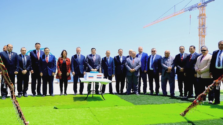
Construction begins of third unit at Egypt's El Dabaa nuclear power plant(图)
埃尔达巴核电站 埃及核和辐射管理局 核工程技术
2023/5/4
Palaeoenvironmental Reconstruction of the Early to Middle Miocene Sequence in West Central Sinai, Egypt, as Revealed from Fossil Diatoms
palaeoenvironment Miocene sequence diatoms west central Sinai Egypt
2018/4/10
A detailed analysis of the diatoms from the sedimentary sequence exposed in Abu Qada basin, west central Sinai, was used to determine the palaeoenvironmental changes during the Lower to Middle Miocene...
POLARIMETRIC SIGNATURES IDENTIFICATION FOR DIFFERENT FEATURES IN RADARSAT-2 POLSAR IMAGE:A CASE STUDY OF HALAYIB AREA,EGYPT
Radarsat-2 PolSAR Polarimetric signatures Pauli decomposition Co-polarization and cross-polarization signature
2016/11/24
In fully polarized SAR (PolSAR) data the returned signal from a target contains all polarizations. More information about this target may be inferred with respect to single-polarization. Distinct pola...
GEOLOGICAL AND STRUCTURAL SETTING OF WADI HODEIN AREA SOUTHEAST EGYPT WITH REMOTE SENSING APPLICATIONS
Wadi Hodein Pan-African ETM Ratio Image
2015/12/29
The Wadi Hodein area in the south Eastern Desert of Egypt is occupied by Neoproterozoic Pan-African (Precambrian) basement rocks including metamorphic and intrusive assemblages. The metamorphic assemb...
SPECTRAL ANALYSIS OF ASTER,HYPERION,AND QUICKBIRD DATA FOR GEOMORPHOLOGICAL AND GEOLOGICAL RESEARCH IN EGYPT (DAKHLA OASIS,WESTERN DESERT)
Hyperspectral remote sensing Classification Image Understanding Principal component analysis Geography DEM Image interpretation Geology
2015/12/29
This paper presents an evaluation, to which degree geological and geomorphological information can be obtained from modern remote sensing systems like the multispectral ASTER or the hyperspectral Hype...
MAPPING SOIL SALINITY USING COLLOCATED COKRIGING IN BAHARIYA OASIS,EGYPT
Soil Salinity Spatial Variability Cokriging Algorithm Colocated Cokriging
2015/9/28
The mapping of saline soils is the first task before any reclamation effort can be conducted. Soil salinity is determined, traditionally, by soil sampling and laboratory analysis. Recently, it became ...
Using Remote Sensing Data for Assessing the Optical Characteristics of Alexandria Coastal Water, Egypt
Coastal Water Quality Remote Sensing Environmental monitoring
2015/7/30
The development of sea surface color data observations has opened new perspectives or the understanding of marine
environmental processes, due to their great potential for providing novel informatio...
EXPLORATION FOR URANIUM AND THORIUM MINERALIZATIONS AT WADI UM LASEIFA AREA, CENTRAL EASTERN DESERT, EGYPT: USING REMOTE SENSING TECHNIQUE
Remote sensing Uranium mineralizations Airborne radiometric data Eastern Desert Granitic rocks
2015/7/29
This research aims at integrating airborne radiometric and remote sensing satellite data to prospect for radioactivity of the rocks at Wadi
Um Laseifa, located in the Central Eastern Desert of Egypt...
ASSESSMENT OF SOIL DEGRADATION IN THE NORTHERN PART OF NILE DELTA, EGYPT USING REMOTE SENSING AND GIS TECHNIQUES
North Nile Delta physical degradation
2015/5/7
The present work aims at monitoring soil degradation process within the last two decades in the northern part of Nile Delta .The investigated area lies between longitudes 31o 00- & 31 o 15- E a...
APPLICATION OF MULTIVARIATE STATISTICS TO STUDY STREAM SEDIMENT DATA FROM THE VICINITY OF LEAD-ZINC OCCURRENCES AT GABAL-RUSAS AREA, EASTERN DESERT,EGYPT
Stream Sediment Survey Lead-Zinc Multivariate Statistics Egypt
2015/2/4
Sixty-seven stream sediment samples were collected in the vicinity of the Miocene Lead-Zinc
occurrences near Gabal El-Rusas Area, and analyzed for their Pb, Zn, Cu, Ni, Co, Mn and Fe contents.
In th...
The Use of the Ordinary Kriging Techniques in measuring the sustainability in Sugar Beet Area,Nubariya,Egypt.
Agric. Sustainability GIS and Geo-statistical analysis
2015/2/3
One of the most important indicators that illustrate the success of the sustainability in the newly reclaimed lands in Egypt is the increase of the stabilization. In this study, a set of villages repr...
Decrease of TSP, PM10, and Lead Concentration in a Lead Company in Alexandria City, Egypt
Air Pollution TSP-PM10-Lead-Dry Wet Filters
2013/3/8
The study was carried out in a lead company inside Alexandria which exists in a residential area. Different sites have been selected inside the Department of Lead Improvement to measure TSP, PM10, and...
Land Use and Land Cover Changes of West Tahta Region, Sohag Governorate, Upper Egypt
Land Use Land Cover Remote Sensing Change Detection
2013/3/5
Due to the growing of population in Egypt during the last few decades, great changes in agricultural area, and urbanization of Egypt art occurred. In this study we utilized the available record of mul...
Comparison of the Groundwater Quality in the West Tahta Area, Upper Egypt in 1989 and 2011
Under Groundwater Withdrawal West Tahta Evaluation of Groundwater
2013/3/12
Egypt is characterized by arid climate with rare rainfall that means surface water. The River Nile is the main source of water supply. The study area is located in Upper Egypt in the western desert. T...
Construction Safety and Occupational Health Education in Egypt, the EU, and US Firms
Occupational Health Workplace Safety Accidents Construction Industry
2013/1/31
The construction industry has been considered an accident prone industry. Alarming statistics indicate thatthe construction industry accounts for 55,000 fatal injuries each year. That is because const...


