
�������: 1-15 ���鵽����ѧ Mars����ؼ�¼63�� . ��ѯʱ��(0.076 ��)
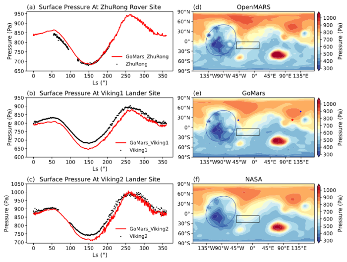
����̽���ǵ�ǰ���Ҹ����Ƽ��������ı�־�����纽��ǿ�������ƻ��Ǵ���ģʽΪ��½ѡַ����ѧ̽���ṩ�������ϡ�Ȼ�����ҹ���ǰ���������з��Ļ��Ǵ���ģʽ���й���ѧԺ���������о��������о��Ŷӻ��������з��ĸ߷ֱ��ʴ���ģʽ������ܣ���չ��Ӧ�������Ǵ������ڴ˻����ϣ������������������ְ�ķ˹�о����ĵĻ����������̣���������һ�����Ǵ���ģʽGlobal Open Planetary atmosph...
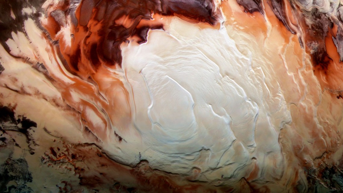
Bright reflections observed at Mars�� south pole serve as evidence for water. But, seeing may be deceiving.
RESEARCH ON THE DIGITAL SIMULATION FOR THE WHOLE PROCESS OF MARS EXPLORATION
Digital simulation Mars exploration Sino-Mars Time-space benchmark Activity object model
2018/6/4
China has paid considerable attention to space exploration and made great strides in the field. The first Chinese Mars Exploration Mission will be carried out in 2020. Digital simulation has been prov...
BATCH CO-REGISTRATION OF MARS HIGH-RESOLUTION IMAGES TO HRSC MC11-E MOSAIC
Automated co-registration orthorectification mosaic MC11-E quadrangle DTM high-resolution data fusion
2016/11/8
Four NASA missions over the last forty years with onboard instruments for high-resolution orbital imaging have achieved both global coverage (with 6m CTX, 20m THEMIS-VIS and >8m Viking Orbiter cameras...
IDENTIFYING SURFACE CHANGES ON HRSC IMAGES OF THE MARS SOUTH POLAR RESIDUAL CAP (SPRC)
data mining Mars south pole HRSC DTM surface change ice caps
2016/11/8
The surface of Mars has been an object of interest for planetary research since the launch of Mariner 4 in 1964. Since then different cameras such as the Viking Visual Imaging Subsystem (VIS), Mars Gl...
EU-FP7-iMARS: ANALYSIS OF MARS MULTI-RESOLUTION IMAGES USING AUTO-COREGISTRATION, DATA MINING AND CROWD SOURCE TECHNIQUES: PROCESSED RESULTS �C A FIRST LOOK
automated DTM and co-registration multi-resolution DTM + ORI CTX HiRISE HRSC webGIS
2016/11/8
Understanding planetary atmosphere-surface exchange and extra-terrestrial-surface formation processes within our Solar System is one of the fundamental goals of planetary science research. There has b...
RADIOMETRIC CALIBRATION OF MARS HiRISE HIGH RESOLUTION IMAGERY BASED ON FPGA
Mar Exploration Radiometric Calibration Field Program Gate Array (FPGA) Digital Signal Processor (DSP) Linear Pushbroom Imagery HiRISE
2016/11/8
Due to the large data amount of HiRISE imagery, traditional radiometric calibration method is not able to meet the fast processing requirements. To solve this problem, a radiometric calibration system...
DENSE IMAGE MATCHING FOR MARS EXPRESS HRSC IMAGERY BASED ON PRECISE POINT PREDICTION METHOD
Mars Exploration Planetary Photogrammetry Mars Topographic Mapping Image Matching High Resolution Stereo Camera
2016/11/8
Currently, Mars Express HRSC imagery is an essential data source to derive high accuracy Mars topographic data. In view of the characteristics of Martian surface satellite imagery, a dense image match...
MASS MOVEMENTS' DETECTION IN HIRISE IMAGES OF THE NORTH POLE OF MARS
Change detection Mass Movements Mars HiRISE
2016/11/8
We are investigating change detection techniques to automatically detect mass movements at the steep north polar scarps of Mars, in order to improve our understanding of these dynamic processes. Here ...
GLOBAL BUNDLE ADJUSTMENT WITH VARIABLE ORIENTATION POINT DISTANCE FOR PRECISE MARS EXPRESS ORBIT RECONSTRUCTION
Planetary Mapping Mars HRSC Bundle Adjustment Orbit Modeling
2016/11/8
The photogrammetric bundle adjustment of line scanner image data requires a precise description of the time-dependent image orientation. For this task exterior orientation parameters of discrete point...
Geomorphologists who study Earth��s surface features and the processes that formed them have long been interested in how floods, in particular catastrophic outbursts that occur when a glacial lake ice ...
New Global Mars control point network
Mars Viking bundle block triangulation control point network
2016/5/20
This paper deals with the computation of a new global control point network of the planet Mars. The existing Mars control point net is based on Viking data and consists of a large number of ground poi...
Mars Pathfinder: Cartographic analysis of the landing site from orbit
Mars Pathfinder Cartographic analysis landing site orbit
2016/5/20
Viking Orbiter stereo images were used to derive a geometrially precise orthoimage mosaic at 40m scale for the Mars Pathfinder landing site. Camera pointing for each images was obtained by a formal bu...
Mars Pathfinder: Photogrammetric processing of lander images
Mars Pathfinder Photogrammetric processing lander images
2016/5/20
The Mars Pathfinder stereo camera (IMP) produced a set of images unique in what they show and unique in the methods they require for their analysis and processing: We first studied the ability of the ...
Towards optimal relief representation from Mars imagery by combination of DEM and shape-from-shading
Mars imagery combination DEM shape-from-shading
2016/5/20
Described are experimental results of a first approach towards optimal shaded relief representation of the surface of Mars derived from Viking Orbiter digital imagery. The complex problem addresses ho...
�й��о����������а�-��
- ���ڼ���...
�й�ѧ���ڿ����а�-��
- ���ڼ���...
�����ѧ���л������а�-��
- ���ڼ���...
�й���ѧ���а�-��
- ���ڼ���...
�ˡ���-ƪ
- ���ڼ���...
�Ρ���-ƪ
- ���ڼ���...
��������-ƪ
- ���ڼ���...
�������� -ƪ
- ���ڼ���...
֪ʶҪ��-ƪ
- ���ڼ���...
���ʶ�̬-ƪ
- ���ڼ���...
��������-ƪ
- ���ڼ���...
ѧ��ָ��-ƪ
- ���ڼ���...
ѧ��վ��-ƪ
- ���ڼ���...