
搜索结果: 1-15 共查到“遥感信息工程 remote sensing”相关记录418条 . 查询时间(0.146 秒)
中国农业大学植物保护学院马占鸿教授团队在IEEE Transactions on Geoscience and Remote Sensing发表研究成果(图)
马占鸿 IEEE Transactions on Geoscience and Remote Sensing 小麦条锈病 遥感
2023/12/11
近日,中国农业大学植物保护学院植病流行与智慧植保实验室马占鸿教授团队在遥感领域国际权威期刊IEEE Transactions on Geoscience and Remote Sensing (TGRS)发表论文“Quantitative Estimation of Wheat Stripe Rust Disease Index Using Unmanned Aerial Vehicle Hype...
Remote Sensing of Environment刊发中国科学院水利部水土保持研究所吕肖良研究员团队日光诱导叶绿素荧光研究工作进展(图)
吕肖良 日光诱导 叶绿素荧光 SIF GPP
2022/6/8
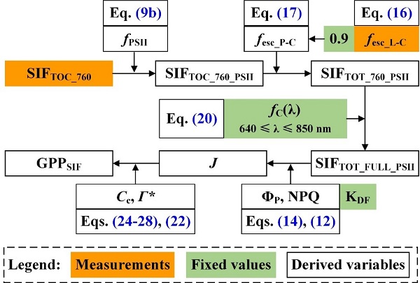
近日,中国科学院水利部水土保持研究所吕肖良研究员团队以西北农林科技大学黄土高原土壤侵蚀与旱地农业国家重点实验室为第一单位在国际遥感领域顶级期刊Remote Sensing of Environment(G1期刊)发表了题为“Direct estimation of photosynthetic CO2 assimilation from solar-induced chlorophyll fluo...

同济大学测绘与地理信息学院王群明教授课题组本科生在遥感领域顶级期刊《Remote Sensing of Environment》发表论文:Blocks-removed spatial unmixing for downscaling MODIS images(图)
同济大学 测绘与地理信息学院 王群明 教授 课题组 遥感领域 顶级期刊
2021/3/18
近日,同济大学测绘与地理信息学院王群明教授课题组在遥感领域顶级期刊《Remote Sensing of Environment》发表了1篇论文。本研究受到国家自然基金项目(41971297)资助。

电子科技大学资源与环境学院定量遥感团队在《ISPRS Journal of Photogrammetry and Remote Sensing》发表研究成果(图)
电子科技大学资源与环境学院 定量遥感 热红外 遥感信息处理 参数反演
2020/8/6
近日,我校资环学院定量遥感团队周纪课题组在卫星被动微波与热红外遥感信息处理和参数反演方面取得重要研究进展。他们在遥感领域顶级期刊《ISPRS Journal of Photogrammetry and Remote Sensing》(一区期刊,影响因子7.319;为国际摄影测量与遥感协会ISPRS会刊)发表了题为“Estimation of 1-km all-weather remotely se...
中国南极测绘研究中心庞小平教授团队海冰遥感研究成果在《Remote Sensing of Environment》发表
中国南极测绘研究中心 庞小平 教授 海冰遥感 研究成果 《Remote Sensing of Environment》
2020/9/7
通过更高分辨率的热红外影像,我们能发现北极海冰的哪些有趣特性?近日,我中心博士生范沛为第一作者,赵羲副教授为通讯作者的研究论文在《环境遥感》发表。该研究基于Landsat 8 TIRS热红外影像,验证了几种经典的温度反演算法在北极海冰区域的精度,并对冰间水道和海冰边缘带的温度特征进行了分析。
LANDSLIDE HAZARD ZONATION MAPPING OF CHAMOLI LANDSLIDES IN REMOTE SENSING AND GIS ENVIRONMENT
Landslides Chamoli Remote Sensing Hazard, Himalaya
2019/2/27
Landslides are very common problem in hilly terrain. Chamoli region of Himalaya is highest sensitive zone of the landslide hazards. The purpose of Chamoli landslide study, to observe the important ter...
MULTITEMPORAL ANALYSIS OF FOREST COVER CHANGE USING REMOTE SENSING AND GIS OF KANHA TIGER RESERVE, CENTRAL INDIA
Forest LULC Livelihood Climate Change Adaptation
2019/2/27
Forest ecosystems play a key role in global ecological balance and provide a variety of tangible and intangible ecosystem services that support the livelihoods of rural poor. In addition to the anthro...
LAND USE CLASSIFICATION FROM COMBINED USE OF REMOTE SENSING AND SOCIAL SENSING DATA
Human Behavior Social Sensing Remote Sensing Decision Tree Geographic Information System Accuracy Assessment
2018/11/9
Large amounts of data can be sensed and analyzed to discover patterns of human behavior in cities for the benefit of urban authorities and citizens, especially in the areas of traffic forecasting, urb...
MAN-MADE OBJECT EXTRACTION FROM REMOTE SENSING IMAGERY BY GRAPH-BASED MANIFOLD RANKING
Man-made Object Extraction Remote Sensing Image Priori Area Extraction Graph Model Manifold Ranking
2018/5/14
The automatic extraction of man-made objects from remote sensing imagery is useful in many applications. This paper proposes an algorithm for extracting man-made objects automatically by integrating a...
TARGETS MASK U-NET FOR WIND TURBINES DETECTION IN REMOTE SENSING IMAGES
object detection VHRRSI wind turbines shadow wide-field detector U-Net
2018/5/14
To detect wind turbines precisely and quickly in very high resolution remote sensing images (VHRRSI) we propose target mask U-Net. This convolution neural network (CNN), which is carefully designed to...
AN INSTANTANEOUS POINT SOURCE DETECTION AND EXTRACTION SYSTEM FOR GEO REMOTE SENSING SATELLITE
Instantaneous Point Source FPGA Remote Sensing Image Reconfigurable
2018/5/14
To accomplish the task of detecting the instantaneous point source, an on-board information real-time processing system is designed which can process the point-source detection with reconfigurable fun...
RESEARCH ON THE CONSTRUCTION OF REMOTE SENSING AUTOMATIC INTERPRETATION SYMBOL BIG DATA
Remote Sensing Automatic Interpretation Symbol Big Data Geographical Conditions Monitoring Crowdsourcing Update Mode Open Evaluation National Wide Application Database Construction
2018/5/14
Remote sensing automatic interpretation symbol (RSAIS) is an inexpensive and fast method in providing precise in-situ information for image interpretation and accuracy. This study designed a scientifi...
VARIABILITY OF REMOTE SENSING SPECTRAL INDICES IN BOREAL LAKE BASINS
Water quality Optically complex waters Remote sensing Hyperspectral imaging Spectral indices
2018/6/4
Remotely sensed hyperspectral data has widely been used to determine water quality parameters in oceanic waters. However in freshwater basins the dependence between the hyperspectral data and the para...
EMERGENCY RESCUE MANAGEMENT SUPPORTED BY UAV REMOTE SENSING DATA
crisis management levee monitoring remote sensing UAV data automatic orthomosaics
2018/5/8
In the proposed SAFEDAM system, aerial and satellite-based information is used for the monitoring of river bodies, flood monitoring during the event, and for post-disaster damage assessment. UAV const...
REMOTE SENSING & GIS INTEGRATION FOR MONITORING THE AREAS AFFECTED BY FOREST FIRES: A CASE STUDY IN IZMIR, TURKEY
Remote Sensing Forest Fire Burn Indexes Classification Sentinel Landsat DEM
2018/5/8
A forest fire is stated as an ecological disaster whether it is man-made or caused naturally. İzmir is one of the regions where forest fires are most intensified in Turkey. The study area located...