搜索结果: 1-15 共查到“Cover”相关记录562条 . 查询时间(0.14 秒)
Land-Cover and Elevation-Based Mapping of Aboveground Carbon in a Tropical Mixed-Shrub Forest Area in West Java, Indonesia
aboveground biomass geostatistics kriging regression modeling stratification tropical forest
2024/1/23
Carbon sequestration and storage are among the most important ecosystem services provided by tropical forests. Improving the accuracy of the carbon mapping of tropical forests has always been a challe...
Convolutional Neural Networks accurately predict cover fractions of plant species and communities in Unmanned Aerial Vehicle imagery
Convolutional Neural Networks (CNN) deep learning invasive species orthophoto remote sensing tree species Unmanned Aerial Vehicles (UAV) vegetation succession
2024/1/19
Unmanned Aerial Vehicles (UAV) greatly extended our possibilities to acquire high resolution remote sensing data for assessing the spatial distribution of species composition and vegetation characteri...
Classifying wetland-related land cover types and habitats using fine-scale lidar metrics derived from country-wide Airborne Laser Scanning
Habitat classification Phragmites australis reedbed structural heterogeneity vegetation complexity wetland conservation
2023/12/19
Mapping 3D vegetation structure in wetlands is important for conservation and monitoring. Openly accessible country-wide Airborne Laser Scanning (ALS) data-using light detection and ranging (lidar) te...
Land Cover and Land Use Change Decreases Net Ecosystem Production in Tropical Peatlands of West Kalimantan, Indonesia
deforestation forest logging tropical climate peat swamp forests oil palm estate NEP
2023/12/8
Deforested and converted tropical peat swamp forests are susceptible to fires and are a major source of greenhouse gas (GHG) emissions. However, information on the influence of land-use change (LUC) o...
Fractional Vegetation Cover Estimation Algorithm for FY-3B Reflectance Data Based on Random Forest Regression Method
fractional vegetation cover FY-3B reflectance data random forest regression method
2023/12/8
As an important land surface vegetation parameter, fractional vegetation cover (FVC) has been widely used in many Earth system ecological and climate models. In particular, high-quality and reliable F...
Airborne LiDAR Intensity Correction Based on a New Method for Incidence Angle Correction for Improving Land-Cover Classification
airborne LiDAR intensity correction LiDAR intensity
2023/12/6
Light detection and range (LiDAR) intensity is an important feature describing the characteristics of a target. The direct use of original intensity values has limitations for users, because the same ...
Climate-Based Regionalization and Inclusion of Spectral Indices for Enhancing Transboundary Land-Use/Cover Classification Using Deep Learning and Machine Learning
machine learning ratio-based indices orthogonal indices Koppen–Geiger climate regionalization landscape change remote sensing landcover
2023/12/4
Accurate land use and cover data are essential for effective land-use planning, hydrological modeling, and policy development. Since the Okavango Delta is a transboundary Ramsar site, managing natural...
Development of Semantic Maps of Vegetation Cover from UAV Images to Support Planning and Management in Fine-Grained Fire-Prone Landscapes
U-Net convolutional neural network (CNN) shrub detection heterogeneous land cover mapping UAV imagery Mediterranean forest
2023/12/1
In Mediterranean landscapes, the encroachment of pyrophytic shrubs is a driver of more frequent and larger wildfires. The high-resolution mapping of vegetation cover is essential for sustainable land ...
Revealing the Structure and Composition of the Restored Vegetation Cover in Semi-Arid Mine Dumps Based on LiDAR and Hyperspectral Images
ecological restoration hierarchical classification vegetation structure LiDAR vegetation species
2023/12/1
Remotely sensed images with low resolution can be effectively used for the large-area monitoring of vegetation restoration, but are unsuitable for accurate small-area monitoring. This limits researche...
Academy of Mathematics and Systems Science, CAS Colloquia & Seminars:A 1.344-approximation algorithm for the vertex cover problem
顶点覆盖问题 1.344 近似算法
2023/12/11
Academy of Mathematics and Systems Science, CAS Colloquia & Seminars:Streaming algorithm for submodular cover problem
子模块化 覆盖问题 流算法
2023/5/15
中国地质大学科学技术发展院陈伟涛 等,计算机学院. Remote Sensing(2019), Fine Land Cover Classification in an Open Pit Mining Area Using Optimized Support Vector Machine and WorldView-3 Imagery
地质环境;遥感;智能;解译;研究领域
2021/10/15
近日,中国地质大学计算机学院陈伟涛副教授团队再次在地质环境遥感智能解译研究领域取得重要进展。相关研究成果发表在国际著名期刊《Remote Sensing》(2018年影响因子为4.118)。论文第一作者为陈伟涛副教授,通讯作者为李显巨副教授。

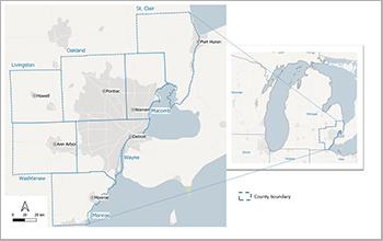
Tree cover increased in Southeast Michigan over the past 30 years(图)
Tree cover increased Southeast Michigan over past 30 years
2020/8/14
The extent of both tree canopy and urban sprawl increased in Southeast Michigan between 1985 and 2015, according to a new University of Michigan study that used aerial photos and satellite i...
Vegetation Cover Estimation Using Convolutional Neural Networks
CNN segmentation UAV vegetation cover estimation
2024/2/4
Vegetation is an important parameter in all bio- and ecosystems, and it should be monitored to conserve and restore the environment. This paper presents a design and implementation of a compact system...

印刷与包装工程学院2017级研究生毕竞泽在《JMCC》发表封面(Front Cover)论文(图)
印刷与包装工程学院 2017级 研究生 毕竞泽 《JMCC》 Front Cover
2019/11/4
北京印刷学院印刷与包装工程学院张春秀教授课题组、2017级研究生毕竞泽同学于2019年9月12号在材料领域知名期刊J. Mater. Chem. C(影响因子:6.641, 中科院JCR一区TOP)上发表题为“Highly ordered columnar superlattice nanostructures with improved charge carrier mobility ...


