
搜索结果: 1-15 共查到“DSM”相关记录99条 . 查询时间(0.066 秒)
中国科学院心理研究所研究揭示DSM-5创伤后应激障碍的临床症状结构
DSM-5 创伤后 应激障碍 临床症状结构
2021/2/5
2013年公布的美国《精神障碍诊断与统计手册》第五版(简称DSM-5)基于实证研究与临床经验对创伤后应激障碍(Posttraumatic stress disorder,PTSD)的临床症状标准进行了多项修改,由此引发了研究者关于PTSD临床症状结构的新一轮探讨。PTSD的临床症状表型之所以受到众多研究者的高度关注,原因在于它是准确界定PTSD的关键;而对PTSD的准确界定又是进一步揭示PTSD的...
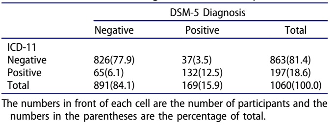
创伤后应激障碍(Posttraumatic stress disorder,PTSD)是创伤事件后常见的心理疾患。目前PTSD的定义和分类主要依靠美国精神病学会(American Psychiatric Association, APA) 制定的《精神障碍的诊断和统计手册(DSM)》 和世界卫生组织(WHO) 制定的《国际疾病和相关健康问题分类(ICD)》。然而,在最新版的DSM-5和ICD-11...
THE STUDY OF WATERSHED TOPOGRAPHY CHARACTERISTICS IN VAKHSH RIVER BASED ON ZY3-DSM
ZY3-DSM the Catchment Boundary Profile Line the Longitudinal Valley Profile Line the Terrain Complexity Indices the Landform Development Indices
2018/5/11
The Vakhsh River is one of the major rivers in Tajikistan. The quantitative analysis of watershed topography and developmental characteristics in Vakhsh River catchment can reflect the morphological c...
A METHOD OF GENERATING DEM FROM DSM BASED ON AIRBORNE INSAR DATA
InSAR DSM Adaptive Threshold Segmentation DEM, Filtering
2018/5/15
Traditional methods of terrestrial survey to acquire DEM cannot meet the requirement of acquiring large quantities of data in real time, but the DSM can be quickly obtained by using the dual antenna s...
UAV-BASED CROPS CLASSIFICATION WITH JOINT FEATURES FROM ORTHOIMAGE AND DSM DATA
UAV crop classification SVM DOM DSMs Texture
2018/5/15
Accurate crops classification remains a challenging task due to the same crop with different spectra and different crops with same spectrum phenomenon. Recently, UAV-based remote sensing approach gain...
THE XII CENTURY TOWERS, A BENCHMARK OF THE ROME COUNTRYSIDE ALMOST CANCELLED: THE SAFEGUARD PLAN BY LOW COST UAV AND TERRESTRIAL DSM PHOTOGRAMMETRY SURVEYING AND 3D WEB GIS APPLICATIONS
XII century towers Rome Mid-Age countryside Cultural Heritage preservation close-range photogrammetry UAV photogrammetry integrated survey low-cost action camera GPS Web GIS 2D and 3D
2018/3/5
This is the consequence of the phenomenon identified with the “Incasalamento” neologism, described in depth in the following paper, intended as the general process of expansion of the urban society in...
GF-7 IMAGING SIMULATION AND DSM ACCURACY ESTIMATE
GF-7 Imaging Simulation WorldView-2 DSM Accuracy Estimate
2017/7/12
GF-7 satellite is a two-line-array stereo imaging satellite for surveying and mapping which will be launched in 2018. Its resolution is about 0.8 meter at subastral point corresponding to a 20 k...
FOSS4G DATE ASSESSMENT ON THE ISPRS OPTICAL STEREO SATELLITE DATA: A BENCHMARK FOR DSM GENERATION
Cartosat-1 Worldview-1 DSM Matching Accuracy FOSS4G
2017/7/13
The ISPRS Working Group 4 Commission I on “Geometric and Radiometric Modelling of Optical Spaceborne Sensors”, provides a benchmark dataset with several stereo data sets from space borne stereo sensor...
FREE GLOBAL DSM ASSESSMENT ON LARGE SCALE AREAS EXPLOITING THE POTENTIALITIES OF THE INNOVATIVE GOOGLE EARTH ENGINE PLATFORM
DSM assessment Google Earth Engine ASTER SRTM geometric accuracy
2017/7/13
The high-performance cloud-computing platform Google Earth Engine has been developed for global-scale analysis based on the Earth observation data. In particular, in this work, the geometric accuracy ...
NEW DTM EXTRACTION APPROACH FROM AIRBORNE IMAGES DERIVED DSM
Digital Surface Model Digital Terrain Model DTM extraction normalised DSM airborne images LiDAR
2017/7/12
In this work, a new filtering approach is proposed for a fully automatic Digital Terrain Model (DTM) extraction from very high resolution airborne images derived Digital Surface Models (DSMs). Our app...
UPGRADE OF FOSS DATE PLUG-IN:IMPLEMENTATION OF A NEW RADARGRAMMETRIC DSM GENERATION CAPABILITY
DSMs generation SAR imagery Free and Open Source Software radargrammetry DSMs merging TerraSAR-X RPCs generation
2016/11/24
Synthetic Aperture Radar (SAR) satellite systems may give important contribution in terms of Digital Surface Models (DSMs) generation considering their complete independence from logistic constraints ...
ACCELERATION OF TOPOGRAPHIC MAP PRODUCTION USING SEMI-AUTOMATIC DTM FROM DSM RADAR DATA
Automatic DTM Classification Topographic Map
2016/11/23
Badan Informasi Geospasial (BIG) is government institution in Indonesia which is responsible to provide Topographic Map at several map scale. For medium map scale, e.g. 1:25.000 or 1:50.000, DSM from ...
ROAD NETWORK EXTRACTION FROM DSM BY MATHEMATICAL MORPHOLOGY AND REASONING
Road extraction Digital Surface Model Morphology
2016/7/8
The objective of this research is the automatic extraction of the road network in a scene of the urban area from a high resolution digital surface model (DSM). Automatic road extraction and modeling f...
APPLICATION OF DSM IN OBSTACLE CLEARANCE SURVEYING OF AERODROME
Obstacle Clearance Surveying Obstacle Limitation Surface Digital Surface Model
2016/7/8
Compared to the wide use of digital elevation model (DEM), digital surface model (DSM) receives less attention because that it is composed by not only terrain surface, but also vegetations and man-mad...
PLEIADES PROJECT:ASSESSMENT OF GEOREFERENCING ACCURACY,IMAGE QUALITY,PANSHARPENING PERFORMENCE AND DSM/DTM QUALITY
Pleiades Georeferencing Accuracy Image Quality Pansharpening DSM/DTM
2016/7/5
Pleiades 1A and 1B are twin optical satellites of Optical and Radar Federated Earth Observation (ORFEO) program jointly running by France and Italy. They are the first satellites of Europe with sub-me...