
搜索结果: 1-15 共查到“Road”相关记录528条 . 查询时间(0.121 秒)

Humans may be one of the biggest roadblocks keeping fully autonomous vehicles off city streets.
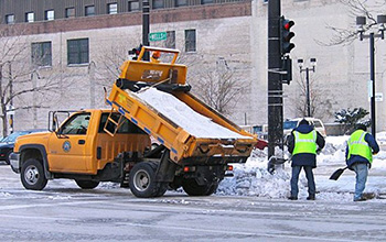
Road salts are threatening world's freshwater supplies(图)
Road salts threatening world freshwater supplies
2021/4/23
When winter storms threaten to make travel dangerous, people often turn to salt, spreading it liberally over highways, streets and sidewalks to melt snow and ice.However, a new study led by Sujay Kaus...
复旦大学中国传统文化的艺术韵味课件 Silk Road
复旦大学 中国传统文化的艺术韵味 课件 Silk Road
2020/12/24
复旦大学中国传统文化的艺术韵味课件 Silk Road。

Silk Road contains genomic resources for improving apples(图)
Silk Road genomic resources improving apples
2020/11/13
The fabled Silk Road -- the 4,000-mile stretch between China and Western Europe where trade flourished from the second century B.C. to the 14th century -- is responsible for one of our favorite and mo...
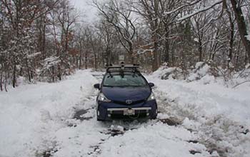
Researchers look under the road to aid self-driving cars(图)
Researchers road aid self-driving cars
2020/3/6
Car companies and researchers have been feverishly working to improve the technologies behind self-driving cars. But so far, even the most high-tech vehicles still fail when it comes to safely navigat...

“敢为人先放飞青春梦,勇立潮头建功新时代”。Bio-road(星火)生物医用纺织材料研发小组在2019年积极参与创新创业大赛,开拓实践,争做时代的弄潮儿。
2019年6月,该团队参加了由教育部等12个中央部委单位和浙江省人民政府共同主办的第五届中国“互联网+”大学生创新创业大赛。本届比赛共有来自全球五大洲124个国家和地区的457万名大学生、109万个团队报名参赛,参赛项目和学生数接近前四届大赛...
ASSESSMENT OF SNOW AVALANCHE SUSCEPTIBILITY OF ROAD NETWORK - A CASE STUDY OF ALAKNANDA BASIN
AHP ASTER GDEM Hazard Snow Avalanche Susceptibility
2019/2/27
Snow avalanche occurring in a micro-climatic condition causing hydro-geo (Hydrological and geological) hazard to the deployed armed forces and nearby inhabitant to the North Western Himalaya about 300...
ROAD NETWORK MAPPING USING AIRBORNE LiDAR DATA
Road Airborne Laser Scanning (ALS) Intensity
2019/2/28
The accurate, detailed and up-to-date road information is highly essential geo-spatial databases for transportation, smart city and other related applications. Thus, the main objective of this researc...
ROAD NETWORK IDENTIFICATION AND EXTRACTION IN SATELLITE IMAGERY USING OTSU'S METHOD AND CONNECTED COMPONENT ANALYSIS
Road identification road extraction Otsu's method connected component analysis morphological operations
2019/2/27
As the high resolution satellite images have become easily available, this has motivated researchers for searching advanced methods for object detection and extraction from satellite images. Roads are...
ROAD EXTRACTION TECHNIQUES FROM REMOTE SENSING IMAGES: A REVIEW
Remote Sensing Image Classification Road Extraction Road Feature
2018/11/9
The importance of analysis high resolution satellite imagery plays an important research topic for geographical information analysis of cities. Geospatial data plays an important role in important iss...
EXPLORATION ON QUANTIFYING CARBON DIOXIDE (CO2) EMISSION FROM ROAD TRAFFIC IN MEGACITY
CO2 emissions Vehicle emissions Traffic census
2018/11/9
As the increasing concern for climate change, quantification on greenhouse gas (GHG) emissions in urban scale has been a key component for local climate actions. To explore an approach on estimating t...
COMBINED VISUAL EXPLORATION OF 2D GROUND RADAR AND 3D POINT CLOUD DATA FOR ROAD ENVIRONMENTS
Ground Penetrating Radar 3D Point Cloud Infrastructure Maintenance
2018/11/9
Ground-penetrating 2D radar scans are captured in road environments for examination of pavement condition and below-ground variations such as lowerings and developing pot-holes. 3D point clouds captur...
MULTI-FEATURE-MARKS BASED INFORMATION EXTRACTION OF URBAN GREEN SPACE ALONG ROAD
High resolution remote sensing imagery Urban green space along road Spectrum features Recognition marks Multi-feature-marks segmentation Information Extraction
2018/5/16
Green space along road of QuickBird image was studied in this paper based on multi-feature-marks in frequency domain. The magnitude spectrum of green along road was analysed, and the recognition marks...
ROAD DAMAGE EXTRACTION FROM POST-EARTHQUAKE UAV IMAGES ASSISTED BY VECTOR DATA
Road damage extraction Damage assessment Earthquake UAV images Object-oriented classification Threshold detection
2018/5/11
Extraction of road damage information after earthquake has been regarded as urgent mission. To collect information about stricken areas, Unmanned Aerial Vehicle can be used to obtain images rapidly. T...
AUTOMATIC EXTRACTION OF ROAD MARKINGS FROM MOBILE LASER-POINT CLOUD USING INTENSITY DATA
Laser Scanning Road Marking Point Cloud High Precision Map Adaptive Threshold Segmentation
2018/5/16
With the development of intelligent transportation, road’s high precision information data has been widely applied in many fields. This paper proposes a concise and practical way to extract road marki...