
�������: 1-15 ���鵽��datasets����ؼ�¼78�� . ��ѯʱ��(0.071 ��)
Synthesizing Disparate LiDAR and Satellite Datasets through Deep Learning to Generate Wall-to-Wall Regional Inventories for the Complex, Mixed-Species Forests of the Eastern United States
LiDAR airborne laser scanning enhanced forest inventory aboveground biomass forest carbon deep learning Maine New Hampshire Vermont Massachusetts Connecticut Rhode Island
2023/12/5
Light detection and ranging (LiDAR) has become a commonly-used tool for generating remotely-sensed forest inventories. However, LiDAR-derived forest inventories have remained uncommon at a regional sc...

Using artificial intelligence to find anomalies hiding in massive datasets��ͼ��
�˹����� ���ݼ� ����ѧϰ���� ��������
2023/6/20
Identifying a malfunction in the nation��s power grid can be like trying to find a needle in an enormous haystack. Hundreds of thousands of interrelated sensors spread across the U.S. capture data on e...
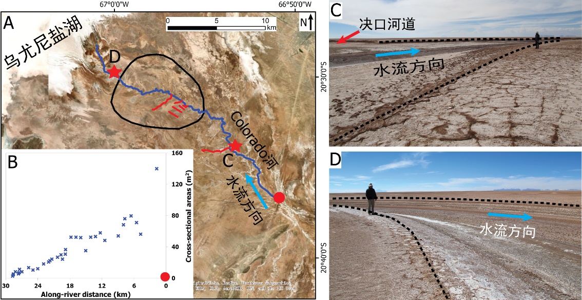
�й����ʴ�ѧ��ѧ������չԺ��ι�* �ȣ���ԴѧԺ. Journal of Hydrology��2020��, Digital Elevation Models for topographic characterisation and flood flow modelling along low-gradient, terminal dryland rivers: A comparison of spaceborne datasets for the R��o Colorado, Bolivia��ͼ��
��ȷ���������ͣ���������ĩ�ˣ����Σ�ģ��ӵ�����ˮ������
2021/10/15
���գ�����֪���ڿ�Journal of Hydrology���߿������й����ʴ�ѧ��ԴѧԺ��ι⸱�����Ŷ���½������Ե����ĩ�˳�����ϵ�о������³ɹ�����Digital Elevation Models for topographic characterisation and flood flow modelling along low-gradient, terminal dryland rive...
MAPPING OF FOREST FIRE BURNED SEVERITY USING THE SENTINEL DATASETS
Sentinel Forest fire NBR dNBR RBR
2019/2/27
Forest fires are frequent phenomena in Uttarakhand Himalayas especially in the months of April to May, causing major loss of valuable forest products and impact on humans through the emissions and the...
ASSESSING THE IMPACT OF CANAL NETWORK ON SURFACE WATERLOGGING USING REMOTE SENSING DATASETS IN ROHTAK DISTRICT, HARYANA
Waterlogging Canals Remote Sensing GIS Rohtak
2019/2/27
Remote Sensing is a very reliable and expeditious technique for assessment and mapping of surface waterlogged areas. In this study band ratio based NDWI index (Normalized Difference Water Index) was u...
ON VOLUME DATA REDUCTION FOR LIDAR DATASETS
LiDAR Redundancy Q-tree Big Data Problem Topography DTM
2018/11/9
This paper discusses a current issue for several experimental science disciplines, which is the Big Data Problem (BDP). This research study focused on light intensity and ranging (LiDAR) datasets, whi...
Efficient Delegated Private Set Intersection on Outsourced Private Datasets
Private Set Intersection Secure Computation Cloud Computing
2018/5/28
Private set intersection (PSI) is an essential cryptographic protocol that has many real world applications. As cloud computing power and popularity have been swiftly growing, it is now desirable to l...
MAPPING GLOBAL OCEAN SURFACE ALBEDO FROM SATELLITE OBSERVATIONS: MODELS, ALGORITHMS, AND DATASETS
Albedo Ocean BRDF Remote sensing Radiative transfer Surface radiation budget
2018/5/14
Ocean surface albedo (OSA) is one of the important parameters in surface radiation budget (SRB). It is usually considered as a controlling factor of the heat exchange among the atmosphere and ocean. T...
RELATIVE ERROR EVALUATION TO TYPICAL OPEN GLOBAL DEM DATASETS IN SHANXI PLATEAU OF CHINA
Relative error false slope ratio typical open global DEM datasets ICESat/GLA14 data Shanxi Plateau
2018/5/16
Produced by radar data or stereo remote sensing image pairs, global DEM datasets are one of the most important types for DEM data. Relative error relates to surface quality created by DEM data, so it ...
A COMPARATIVE ANALYSIS OF FIVE CROPLAND DATASETS IN AFRICA
Africa Land cover Cropland area Spatial location Accuracy
2018/5/15
The food security, particularly in Africa, is a challenge to be resolved. The cropland area and spatial distribution obtained from remote sensing imagery are vital information. In this paper, accordin...
GENERATION OF GROUND TRUTH DATASETS FOR THE ANALYSIS OF 3D POINT CLOUDS IN URBAN SCENES ACQUIRED VIA DIFFERENT SENSORS
Different sensors Point clouds Multi-resolution voxel structure 3D space labeling
2018/5/16
In this work, we report a novel way of generating ground truth dataset for analyzing point cloud from different sensors and the validation of algorithms. Instead of directly labeling large amount of 3...
FUSING PANCHROMATIC AND SWIR BANDS BASED ON CNN �C A PRELIMINARY STUDY OVER WORLDVIEW-3 DATASETS
Pan-sharpening, Convolutional Neural Network, Short-wave Infrared, Deep Learning, Image fusion, Remote Sensing
2018/5/14
The traditional fusion methods are based on the fact that the spectral ranges of the Panchromatic (PAN) and multispectral bands (MS) are almost overlapping. In this paper, we propose a new pan-sharpen...
A METADATA BASED APPROACH FOR ANALYZING UAV DATASETS FOR PHOTOGRAMMETRIC APPLICATIONS
UAV Metadata Filtration Photogrammetry
2018/6/4
This paper proposes a methodology for pre-processing and analysing Unmanned Aerial Vehicle (UAV) datasets before photogrammetric processing. In cases where images are gathered without a detailed fligh...
A VARIANT OF LSD-SLAM CAPABLE OF PROCESSING HIGH-SPEED LOW-FRAMERATE MONOCULAR DATASETS
monocular visual odometry filter-based visual odometry Augmented Reality
2018/3/6
We develop a new variant of LSD-SLAM, called C-LSD-SLAM, which is capable of performing monocular tracking and mapping in high-speed low-framerate situations such as those of the KITTI datasets. The m...

UW Study of Global Datasets Reveals Significant Role of Dust in Mountain Ecosystems��ͼ��
UW Study Global Datasets Dust Mountain Ecosystems
2017/12/19
Trees growing atop the Bald Mountain Granite in the southern Sierra Nevada rely on nutrients from windblown atmospheric dust -- more than 50 percent -- compared to nutrients provided from underlying b...
�й��о����������а�-��
- ���ڼ���...
�й�ѧ���ڿ����а�-��
- ���ڼ���...
�����ѧ���л������а�-��
- ���ڼ���...
�й���ѧ���а�-��
- ���ڼ���...
�ˡ���-ƪ
- ���ڼ���...
�Ρ���-ƪ
- ���ڼ���...
��������-ƪ
- ���ڼ���...
�������� -ƪ
- ���ڼ���...
֪ʶҪ��-ƪ
- ���ڼ���...
���ʶ�̬-ƪ
- ���ڼ���...
��������-ƪ
- ���ڼ���...
ѧ��ָ��-ƪ
- ���ڼ���...
ѧ��վ��-ƪ
- ���ڼ���...