
搜索结果: 1-15 共查到“valley”相关记录219条 . 查询时间(0.062 秒)
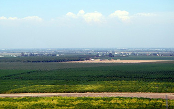
Researchers use satellite imaging to map groundwater use in California's Central Valley(图)
satellite imaging map groundwater California Central Valley
2020/10/16
Researchers at the University of California, San Diego report a new way to improve groundwater monitoring by using a remote sensing technology, known as InSAR (interferometric synthetic aper...
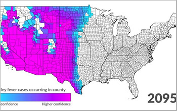
Scientists project northward expansion of Valley fever by end of 21st century(图)
Scientists northward expansion Valley fever 21st century
2019/10/18
Valley fever is endemic to hot, dry regions such as California's San Joaquin Valley in the southwestern United States, but scientists at the University of California, Irvine predict that climate chang...
中国地质大学科学技术发展院刘红叶(博士研究生),顾延生* 等 环境学院 Quaternary Science Reviews (2019), A 13,000-year peatland palaeohydrological response to the ENSO-related Asian monsoon precipitation changes in the middle Yangtze Valley
长江中游地区;湖沼;湿地;季风;水文;驱动机制
2021/10/20
2019年4月8日,《Quaternary Science Reviews》在线刊发了中国地质大学环境学院顾延生教授团队题为《长江中游泥炭地13000年来古水文响应ENSO关联的亚洲季风降雨》(A 13,000-year peatland palaeohydrological response to the ENSO-related Asian monsoon precipitation chan...
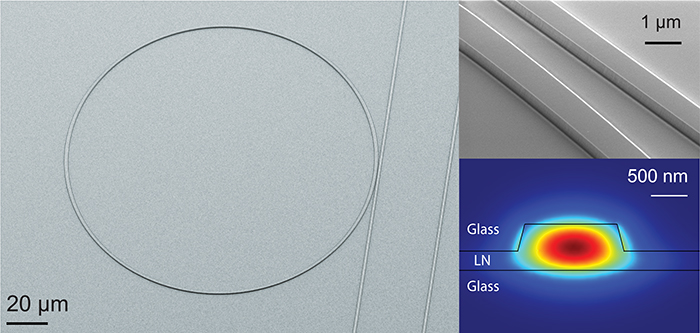
If the epicenter of the electronics revolution is named after the material that made it possible ― silicon ― then the birthplace of the photonics revolution may well be named after lithium niobate. Wh...

2017年5月18日,我校杨小平教授在2017年韩国春季碳会议上荣获“Carbon Valley Award”( 碳谷奖)。这是韩国碳学会新设立的奖项,用于奖励对碳材料工业发展做出突出贡献的科学家,杨小平教授是该奖项的首位获奖人。杨小平教授研究团队一直致力于碳材料研究,在中韩碳材料领域的学术和工业界国际交流与合作发挥了积极作用,通过中韩政府间国际合作项目、中韩双边学术会议以及师生双边互访等多种形式...
LEARNING GEOMATICS FOR RESTORATION: ICOMOS SUMMER SCHOOL IN OSSOLA VALLEY
Cultural Heritage rural village geomatics survey conservation
2017/6/20
Documentation and preservation of widespread rural heritage are today possible only if you can activate processes of conservation headed by local communities, thereby recognizing the link between the ...
MULTIPLE 3D APPROACHES FOR THE ARCHITECTURAL STUDY OF THE MEDIEVAL ABBEY OF CORMERY IN THE LOIRE VALLEY
Archaeology Architecture Church Drawing
2017/4/10
This paper will focus on the technical approaches used for a PhD thesis regarding architecture and spatial organization of benedict abbeys in Touraine in the Middle Ages, in particular the abbey of Co...
A SPATIAL ANALYSIS ON GIS-HEDONIC PRICING MODEL ON THE INFLUENCE OF PUBLIC OPEN SPACE AND HOUSE PRICE IN KLANG VALLEY,MALAYSIA
GIS Hedonic Pricing Model Public Open Space House Price Malaysia
2016/12/1
Presently, it is noticeable that there is a significant influence of public open space about house price, especially in many developed nations. Literature suggests the relationship between the two asp...
Cuyahoga Valley National Park,Kent State&Cleveland Metroparks launch learning app
Cuyahoga Valley National Park Kent State&Cleveland Metroparks learning app
2016/6/12
Educators, scientists, and technologists from the Cuyahoga Valley National Park, Kent State University and Cleveland Metroparks have partnered to develop a new learning app that is now live and freely...
Burial sites show how Nubians,Egyptians integrated communities thousands of years ago in Nile River Valley area
Burial sites Nubians Egyptians integrated communities Nile River Valley area
2016/5/31
New bioarchaeological evidence shows that Nubians and Egyptians integrated into a community, and even married, in ancient Sudan, according to new research from aPurdue University anthropologist.“...
EVALUATION OF CHANGES IN ATLANTIC FOREST (VALLEY OF CUNA PIRU,MISIONES,ARGENTINA) WITH MULTI-TEMPORAL SATELLITE DATA
forestry change detection classification multi-temporal monitoring prediction management
2015/12/31
The forest in the province of Misiones, northeastern of Argentina, is a portion of Paraná Forest (or Atlantic Forest) located also in the south of Brasil and Paraguay. At the beginning of the last cen...
REMOTE SENSING GEOBOTANY AND AIRBORNE GAMMA-RAY DATA APPLIED TO GEOLOGICAL MAPPING WITHIN TERRA FIRME BRAZILIAN AMAZON FOREST:A COMPARATIVE STUDY IN THE GUAPORE VALLEY (MATO GROSSO STATE,BRAZIL)
Remote Sensing Geology Geophysics Mapping Forestry Multispectral ASTER
2015/12/29
This paper comprises a comparison between the vegetation response in ASTER (Advanced Spaceborne Thermal Emission and Reflection Radiometer) multispectral optical imagery and possibly equivalent bedroc...
SPATIAL STRUCTURE OF LAND USE DYNAMICS IN KATHMANDU VALLEY
Land Use Human Settlement Change Detection Multitemporal Urban Landscape Developing Countries
2015/12/26
Quantifying landscape pattern and its change are essential for the monitoring and assessment of environmental consequences of urban area. This paper aims to analyze spatiotemporal patterns of urban la...
Climate models used to explain formation of Mars valley networks
Climate models Mars valley networks
2015/11/13
The extensive valley networks on the surface of Mars were probably created by running water billions of years ago, but the source of that water is unknown. Now, a team of Penn State and NASA researche...
Electrical imaging and self-potential survayes to study the geological setting of the Quaternary, slope depositsin the Agri high valley (Southern Italy)
Electrical imaging self potential structural geology slope deposits strike-slip fault
2015/9/28
We present the results of a geophysical survey carried out to outline the structural modelling of Quaternary slopedeposits in the northern part of the Agri high valley (Basilicata, Southern Italy). Qu...