
搜索结果: 1-15 共查到“理学 datasets”相关记录21条 . 查询时间(0.025 秒)
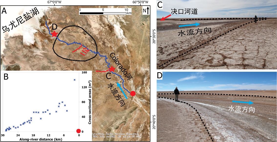
中国地质大学科学技术发展院李嘉光* 等,资源学院. Journal of Hydrology(2020), Digital Elevation Models for topographic characterisation and flood flow modelling along low-gradient, terminal dryland rivers: A comparison of spaceborne datasets for the Río Colorado, Bolivia(图)
精确表征;极低;缓河流;末端;地形;模拟河道;洪水;漫溢
2021/10/15
近日,国际知名期刊Journal of Hydrology在线刊发了中国地质大学资源学院李嘉光副教授团队在陆相湖盆边缘河流末端沉积体系研究的最新成果――Digital Elevation Models for topographic characterisation and flood flow modelling along low-gradient, terminal dryland rive...
ASSESSING THE IMPACT OF CANAL NETWORK ON SURFACE WATERLOGGING USING REMOTE SENSING DATASETS IN ROHTAK DISTRICT, HARYANA
Waterlogging Canals Remote Sensing GIS Rohtak
2019/2/27
Remote Sensing is a very reliable and expeditious technique for assessment and mapping of surface waterlogged areas. In this study band ratio based NDWI index (Normalized Difference Water Index) was u...
RELATIVE ERROR EVALUATION TO TYPICAL OPEN GLOBAL DEM DATASETS IN SHANXI PLATEAU OF CHINA
Relative error false slope ratio typical open global DEM datasets ICESat/GLA14 data Shanxi Plateau
2018/5/16
Produced by radar data or stereo remote sensing image pairs, global DEM datasets are one of the most important types for DEM data. Relative error relates to surface quality created by DEM data, so it ...

UW Study of Global Datasets Reveals Significant Role of Dust in Mountain Ecosystems(图)
UW Study Global Datasets Dust Mountain Ecosystems
2017/12/19
Trees growing atop the Bald Mountain Granite in the southern Sierra Nevada rely on nutrients from windblown atmospheric dust -- more than 50 percent -- compared to nutrients provided from underlying b...
SEMI-AUTOMATED APPROACH FOR MAPPING URBAN TREES FROM INTEGRATED AERIAL LiDAR POINT CLOUD AND DIGITAL IMAGERY DATASETS
Extraction Integrated Airborne LiDAR Multispectral Image Urban Trees
2016/10/14
Mapping of trees plays an important role in modern urban spatial data management, as many benefits and applications inherit from this detailed up-to-date data sources. Timely and accurate acquisition ...
VISUALIZING AND ANALYZING LARGE AND DETAILED 3D DATASETS
Multi-resolution modeling interactive visualization GPU programming large datasets texture mapping
2015/10/8
This paper presents a set of tools developed to model, visualize and analyze large 3D datasets built from 2D and 3D sensor data. These
tools, grouped under the Atelier3D framework, first includ...
Integration of geophysical datasets by a conjoint probability tomography approach: application to Italian active volcanic areas
integration of geophysical methods probability tomography active volcanic areas
2015/9/1
We expand the theory of probability tomography to the integration of different geophysical datasets. The aim of
the new method is to improve the information quality using a conjoint occurrence probab...
A summary of hazard datasets and guidelines supported by the Global Earthquake Model during the first implementation phase
Global datasets Seismic hazard Global earthquake model
2015/8/17
The Global Earthquake Model (GEM) initiative promotes open, transparent and collaborative science aimed at the assessment of earthquake risk and its reduction worldwide. During the first implementatio...
A summary of hazard datasets and guidelines supported by the Global Earthquake Model during the first implementation phase
Global datasets Seismic hazard Global earthquake model
2015/8/14
The Global Earthquake Model (GEM) initiative promotes open, transparent and collaborative science aimed at the assessment of earthquake risk and its reduction worldwide. During the first implementatio...
Validation of spectral continuity between PROBA-V and SPOT-VEGETATION global daily datasets
PROBA-V Global Daily
2015/5/7
Spectral consistency with SPOT-VEGETATION is an important mission objective for PROBA-V, in particular for its 1 km products. This must allow service providers such as the Copernicus Global Land Ser...
Re-evaluation of the Mentelle Basin, a polyphase rifted margin basin, offshore southwest Australia: new insights from integrated regional seismic datasets
the Mentelle Basin a polyphase rifted margin basin offshore southwest Australia integrated regional seismic datasets
2014/12/31
Vintage 2-D (two-dimensional) seismic reflection surveys from the sparsely explored Mentelle Basin (western Australian margin) have been reprocessed and integrated with a recent high-quality 2-D seism...
Critical Metadata Protocols in Hyperspectral Field Campaigns for Building Robust Hyperspectral Datasets
Databases Data mining Hyperspectral, Metadata Calibration Data Quality Interoperability Standards
2014/4/25
Field spectroscopic metadata is a central component in the quality and reliability of hyperspectral data and the products derived from it. The impact of the quantity and format of metadata created at ...
Space-time variability of hydrological drought and wetness in Iran using NCEP/NCAR and GPCC datasets
Space-time variability hydrological drought wetness NCEP/NCAR
2010/12/22
Space-time variability of hydrological drought and wetness over Iran is investigated using the National Centers for Environmental Prediction/National Center for Atmospheric Research (NCEP/NCAR) reanal...
Delensing CMB Polarization with External Datasets
Cosmology and Extragalactic Astrophysics (astro-ph.CO)
2010/12/22
One of the primary scientific targets of current and future CMB polarization experiments is the search for a stochastic background of gravity waves in the early universe. As instrumental sensitivity i...
Organic aerosol components observed in Northern Hemispheric datasets from Aerosol Mass Spectrometry
Organic aerosol components Northern Hemispheric Aerosol Mass Spectrometry
2010/8/13
In this study we compile and present results from the factor analysis of 43 Aerosol Mass Spectrometer (AMS) datasets (27 of the datasets are reanalyzed in this work). The components from all sites, wh...