
搜索结果: 1-15 共查到“工学 LEVELS”相关记录83条 . 查询时间(0.156 秒)
Academy of Mathematics and Systems Science, CAS Colloquia & Seminars:Dual Control for High Levels of Automation in Uncertain Environments
双重控制 不确定 环境 自动化
2023/5/8
For a system operating in an unknown or changing environment, it is desirable to design a control system to keep it always operating at its best possible performance (e. g. in terms of productivity or...
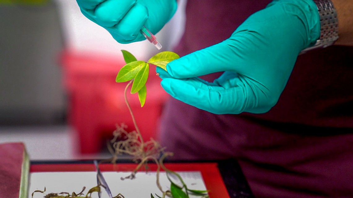
Water regulation in leaves is vital to a plant’s health, affecting its growth and yield, disease susceptibility and drought resistance.

It is not uncommon to find aluminum in municipal water systems. It's part of some water treatment processes. Recently, however, aluminum has been discovered in deposits that form on lead water pipes, ...
Study finds mercury levels in Arctic soils 5 times higher than temperate regions
mercury levels Arctic soils 5 times higher temperate regions
2017/7/24
Plants and soil in the Arctic tundra absorb and store mercury released into the atmosphere by industry and mining in the Earth's temperate regions, leading to soil mercury levels five times higher tha...
Rising sea levels will boost moderate floods in some areas,severe floods in others
Rising sea levels boost moderate floods some areas severe floods
2017/7/21
The study by researchers at Princeton and Rutgers universities found that along the southeastern coast, where severe flooding due to hurricanes is relatively frequent, cities such as Charles...
EXTENSION OF RTKLIB FOR THE CALCULATION AND VALIDATION OF PROTECTION LEVELS
GNSS SBAS integrity protection level RTKLIB
2017/8/10
System integrity (i.e. the capability of self-monitoring) and the reliability of the positions provided need to be ensured within all safety critical applications of the GPS technology. For the sake o...
Against the Tide:Fish Quickly Adapt to Lethal Levels of Pollution
Tide Fish Quickly Adapt Lethal Pollution
2016/12/13
Evolution is allowing some urban fish to survive in a lethal, human-altered environment, according to new results published in the journal Science.
While environmental change is outpacing the rate of...
CHARACTERISTICS OF THE REMOTE SENSING DATA USED IN THE PROPOSED UNFCCC REDD+FOREST REFERENCE EMISSION LEVELS (FRELS)
Earth observation climate change land-use change REDD+ forest carbon inventory national forest monitoring system deforestation forest degradation
2016/11/30
Developing countries must submit forest reference emission levels (FRELs) to the UNFCCC to receive incentives for REDD+ activities (e.g. reducing emissions from deforestation/forest degradation, susta...
AN ORIGINAL PROCESSING METHOD OF SATELLITE ALTIMETRY FOR ESTIMATING WATER LEVELS AND VOLUME FLUCTUATIONS IN A SERIES OF SMALL LAKES OF THE PANTANAL WETLAND COMPLEX IN BRAZIL
Satellite altimetry Envisat Saral Waveform Retracker Water level Small lakes Pantanal
2016/11/30
Satellite altimetry is becoming a major tool for measuring water levels in rivers and lakes offering accuracies compatible with many hydrological applications, especially in uninhabited regions of dif...
Maryland school district showcases computer science education at all levels
Maryland school district computer science education at all levels
2016/9/29
To visit the Charles County Public Schools in southern Maryland, about an hour outside of Washington, D.C., is to get a sense of what computer science education may look like nationwide in the near fu...
AUTOMATIC GENERATION OF BUILDING MODELS WITH LEVELS OF DETAIL 1-3
Building Model Orientation 3D Reconstruction Point Cloud Segmentation
2016/7/28
We present a workflow for the automatic generation of building models with levels of detail (LOD) 1 to 3 according to the CityGML standard (Gröger et al., 2012). We start with orienting unsorted ...
Fusion of different data levels within Geographic Information Systems
Forestry Information System Satellite Data Ancillary Data Data Fusion Forest Planning
2016/5/23
In this document methods for the fusion of different GIS-data with remote sensing data will be demonstrated and discussed by the help of a practical example of its application. The objective of the pr...
DIGITAL PHOTOGRAMMETRY REACHES GRASS ROOT LEVELS IN INDIA
Photogrammetry Developing Countries Digital Land Measurement National Future
2016/1/3
Revenue surveys initiated by East India Company towards the end of 18th Century remained the responsibility of Survey of India established in 1767 till 1904 and later came under the State government D...
INTEGRATION OF REMOTE SENSING DATA AND BASIC GEODATA AT DIFFERENT SCALE LEVELS FOR IMPROVED LAND USE ANALYSES
GIS Land Use Digital Landscape Model Cadastral Data WorldView-2 ATKIS ALK Multi Data Approach
2015/9/21
The classification of remote sensing data is a standard method to retrieve up-to-date land use data at various scales. However, through the incorporation of additional data using geographical informat...
Comparison and analysis of remote sensing data fusion techniques at feature and decision levels
Remote Sensing Image Fusion Data Fusion
2015/8/21
Image fusion is the combination of two or more different images to form a new image by using a certain algorithm. The aim of
image fusion is to integrate complementary data in order to obtain more an...