
�������: 1-15 ���鵽����ѧ local����ؼ�¼222�� . ��ѯʱ��(0.091 ��)
Academy of Mathematics and Systems Science, CAS Colloquia & Seminars��An active contour model with local variance force term and its efficient minimization solver for multi-phase image
�ֲ��������� �����ģ�� ����ͼ�� ��С�������
2023/5/8
In this work, we propose an active contour model with a local variance force (LVF) term that can be applied to multi-phase image segmentation problems. With the LVF, the proposed model is very effecti...
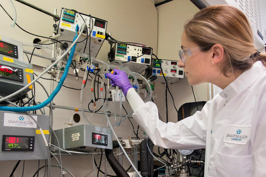
Speeding up clinical trials by making drug production local��ͼ��
ҩƷ�������ػ� �ٴ����� ��ҩ����
2023/6/8
The Boston area has long been home to innovation that leads to impactful new drugs. But manufacturing those drugs for clinical trials often involves international partners and supply chains. The vulne...
OPEN NETWORK FOR LOCAL SELF SUSTAINABILITY, BOOSTING BIOREGIONAL DEVELOPMENT THROUGH AN OPEN DATA SHARING SYSTEM
Self sustainability Spatial Data Sharing Systems geo-referenced LCA data
2018/11/8
The paper presents an online geodatabase currently under development. Its name is Open NETwork for Local Self Sustainability and the website address is www.oloss.net.The goal of this platform is to pu...
BUILT-UP AREA DETECTION FROM HIGH-RESOLUTION SATELLITE IMAGES USING MULTI-SCALE WAVELET TRANSFORM AND LOCAL SPATIAL STATISTICS
Built-up Area Detection High-resolution Satellite Image Wavelet Transform Local Spatial Statistics
2018/5/11
Recently, built-up area detection from high-resolution satellite images (HRSI) has attracted increasing attention because HRSI can provide more detailed object information. In this paper, multi-resolu...
GF-3 SAR IMAGE DESPECKLING BASED ON THE IMPROVED NON-LOCAL MEANS USING NON-SUBSAMPLED SHEARLET TRANSFORM
GF-3 SAR non-subsampled Shearlet transform image despeckling improved Non-Local Means
2018/5/15
GF-3 synthetic aperture radar (SAR) images are rich in information and have obvious sparse features. However, the speckle appears in the GF-3 SAR images due to the coherent imaging system and it hinde...
THRESHOLD DETERMINATION FOR LOCAL INSTANTANEOUS SEA SURFACE HEIGHT DERIVATION WITH ICEBRIDGE DATA IN BEAUFORT SEA
IceBridge optimal threshold Sea surface reference Beaufort sea
2018/5/17
The NASA Operation IceBridge (OIB) mission is the largest program in the Earth��s polar remote sensing science observation project currently, initiated in 2009, which collects airborne remote sensing m...
DEVELOPING GIS-BASED DISASTER MANAGEMENT SYSTEM FOR LOCAL AUTHORITY �C CASE STUDY IN MALAYSIA
GIS Map publishing Disaster management
2018/4/18
This paper describes the development of geospatial-based disaster management system for an agency at regional level. Important aspects of the system such as spatial data, geospatial database, interfac...
DEVELOPING GIS-BASED DISASTER MANAGEMENT SYSTEM FOR LOCAL AUTHORITY �C CASE STUDY IN MALAYSIA
GIS Map publishing Disaster managemen
2018/5/8
This paper describes the development of geospatial-based disaster management system for an agency at regional level. Important aspects of the system such as spatial data, geospatial database, interfac...
BRIDGING THE GAP BETWEEN GLOBAL AND LOCAL STRATEGIES OF ARCHITECTURAL CONSERVATION, EXAMPLES OF THE CURRENT SCENARIOS IN INDIA
Maintenance Indian Context Indian Temples. Monitoring Latest Technologies Image Based Diagnostics
2017/6/20
Culture develops from a civilization and progresses through the generations in tangible and intangible forms affecting various aspects of living. It gradually becomes a rulebook that guides the way of...
TOWARDS CONSISTENT MAPPING OF URBAN STRUCTURES�CGLOBAL HUMAN SETTLEMENT LAYER AND LOCAL CLIMATE ZONES
Local Climate Zones Global Human Settlement Layer LULC Urban Structure Urban Systems
2016/12/1
Although more than half of the Earth��s population live in urban areas, we know remarkably little about most cities and what we do know is incomplete (lack of coverage) and inconsistent (varying defini...
IDENTIFYING LOCAL SCALE CLIMATE ZONES OF URBAN HEAT ISLAND FROM HJ-1B SATELLITE DATA USING SELF-ORGANIZING MAPS
Urban heat island Local climate zones Impervious surface area Land surface temperature Surface albedo Self-organization maps
2016/12/1
With the increasing acceleration of urbanization, the degeneration of the environment and the Urban Heat Island (UHI) has attracted more and more attention. Quantitative delineation of UHI has become ...
ACADEME-LOCAL GOVERNMENT PARTNERSHIP TOWARDS EFFECTIVE APPLICATION OF GEOSPATIAL TECHNOLOGIES FOR SMARTER FLOOD DISASTER MANAGEMENT AT THE LOCAL LEVEL:AN EXAMPLE FROM MINDANAO,PHILIPPINES
Geospatial technology Flood Disaster management Academe-local government partnership Mindanao Philippines
2016/11/30
In this paper, we discuss how an academe-local government partnership can lead the way for the effective use of geospatial technologies for smarter and geospatially-informed decision making before, du...
MAPPING OF INNER AND OUTER CELESTIAL BODIES USING NEW GLOBAL AND LOCAL TOPOGRAPHIC DATA DERIVED FROM PHOTOGRAMMETRIC IMAGE PROCESSING
Planetary cartography DEM geomorphology study Phobos the Moon Mercury Ganymede and Enceladus
2016/11/8
New estimation of fundamental geodetic parameters and global and local topography of planets and satellites provide basic coordinate systems for mapping as well as opportunities for studies of process...
CENTIMETER-LEVEL, ROBUST GNSS-AIDED INERTIAL POST-PROCESSING FOR MOBILE MAPPING WITHOUT LOCAL REFERENCE STATIONS
Differential GNSS Sensor Orientation Mobile Mapping GNSS-Aided Inertial Georeferenicng Airborne Mapping Direct Geroeferencing PPP
2016/7/28
For almost two decades mobile mapping systems have done their georeferencing using Global Navigation Satellite Systems (GNSS) to measure position and inertial sensors to measure orientation. In order ...
EVALUATION OF WAVELET AND NON-LOCAL MEAN DENOISING OF TERRESTRIAL LASER SCANNING DATA FOR SMALL-SCALE JOINT ROUGHNESS ESTIMATION
terrestrial laser scanning range noise data resolution joint roughness wavelet transform non-local mean denoising performance
2016/7/27
Terrestrial Laser Scanning (TLS) is a well-known remote sensing tool that enables precise 3D acquisition of surface morphology from distances of a few meters to a few kilometres. The morphological rep...
�й��о����������а�-��
- ���ڼ���...
�й�ѧ���ڿ����а�-��
- ���ڼ���...
�����ѧ���л������а�-��
- ���ڼ���...
�й���ѧ���а�-��
- ���ڼ���...
�ˡ���-ƪ
- ���ڼ���...
�Ρ���-ƪ
- ���ڼ���...
��������-ƪ
- ���ڼ���...
�������� -ƪ
- ���ڼ���...
֪ʶҪ��-ƪ
- ���ڼ���...
���ʶ�̬-ƪ
- ���ڼ���...
��������-ƪ
- ���ڼ���...
ѧ��ָ��-ƪ
- ���ڼ���...
ѧ��վ��-ƪ
- ���ڼ���...