搜索结果: 1-14 共查到“大地测量学 Earth”相关记录14条 . 查询时间(0.084 秒)

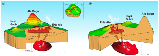
近日,我校地球科学与信息物理学院-雷达遥感实验室-火山与地震研究课题组许文斌教授领衔的跨学科研究团队在地学领域国际地学权威期刊、自然指数期刊(NI68)之一的《Journal of Geophysical Research: Solid Earth》发表了题为“Volcano‐Wide Deformation After the 2017 Erta Ale Dike Intrusion, Ethi...
Experience of Russian Geoportals Based on Earth Remote Sensing Data
Geoportals Space Images Geoinformation Services Remote Sensing
2015/12/17
Quick development of information technologies lately had an impact on traditional methods to search, to process and to display geographic information. Obviously this happens due to the geoinformatics ...
Effects of gradients of the electron density on Earth-space communications
Electron density space
2015/9/14
This paper is a review of the main results achieved in the framework of COST 271 Action Working Group 4, under the activities of the Work Package 4.4. The first topic treated deals with the influence ...
Tailoring space solutions for operational earth observation usage
Earth Observation operational missions EO data continuity space segment, new missions affordability
2015/9/1
The volume and diversity of institutional and commercial downstream applications using Earth Observation satellites (cartography,land cover, agriculture, natural and industrial risks management, human...
A new era of highly miniaturized space technologies, allowing to develop high performing, light and affordable earth observation missions
highly miniaturized space technologies affordable earth observation missions
2015/9/1
For many years Alcatel Alenia Space has been developing multi -mission concept of satellites for Low Earth Orbit (LEO) scientific or observation applicatio ns. These developments led to seve ral famil...
Thailand earth observation system:mission and products
Small Satellite Fusion Image Push -broom THEOS High Resolution Optical sensor
2015/9/1
It consists of design, development, test, launch, and commissioning phases of THEOS satellite, as well as integration...
Three years continuous record of the Earth’s magnetic field at Concordia Station (DomeC, Antarctica)
Antarctica DomeC magnetic observatory continuos records
2015/8/28
The magnetic observatory deployed at DomeC, Antarctica, in the French-Italian base known as Concordia has now been permanently running for more than three years. This paper focuses on these long-term ...
Connections Between Ocean Bottom Topography and Earth's Climate
Ocean Bottom Topography Earth's Climate
2015/7/29
The seafloor is one of the critical controls on the ocean's general circulation. Its influence comes through a variety of mechanisms including the contribution of mixing in the ocean's interior throug...
Digital Earth Visualization and Web-interface Capabilities Utilizing 3-d Geobrowser Technology
Three-dimensional Visualization Virtual Reality
2015/7/8
Since the early days of the first Earth monitoring satellite launches, the ability to distribute these important data resources to the
world community has been especially challenging. This chronic sh...
THE SUN-EARTH SPACE INFORMATION SYSTEM
Spatial Information Sciences Extra-terrestrial Application Visualization Model Virtual Reality
2015/6/1
Nowadays the object of Space Information System (SIS) is limited to the earth surface, and the large-scale sun-earth space does not been considered. In this paper, the research object of SIS is been e...
DATA MINING AND KNOWLEDGE DISCOVERY TOOLS FOR EXPLOITING BIG EARTH OBSERVATION DATA
Systems to manage Earth-Observation images
2015/5/6
The continuous increase in the size of the archives and in the variety and complexity of Earth-Observation (EO) sensors require new methodologies and tools that allow the end-user to access a large i...
RAPID RESPONSE TOOLS AND DATASETS FOR POST-FIRE MODELING: LINKING EARTH OBSERVATIONS AND PROCESS-BASED HYDROLOGICAL MODELS TO SUPPORT POST-FIRE REMEDIATION
Forestry, Hydrology Hazards Forest fire
2015/5/6
Preparation is key to utilizing Earth Observations and process-based models to support post-wildfire mitigation. Post-fire flooding and erosion can pose a serious threat to life, property and munici...
Studying Earth Change with NASA ’s Scientific Data Buy Program
The earth changes NASA scientific data
2015/2/4
Studying Earth Change with NASA ’s Scientific Data Buy Program.

Professor Barry Parsons,Department of Earth Sciences at University of Oxford(图)
Professor Barry Parsons Department of Earth Sciences at University of Oxford Geodesy Geophysics
2014/3/10


