搜索结果: 1-9 共查到“农学总论 mapping”相关记录9条 . 查询时间(0.249 秒)
Four-leaved clovers may or may not bring good luck. What's indisputable is that all white clovers, whether with three or four leaves, have many benefits.

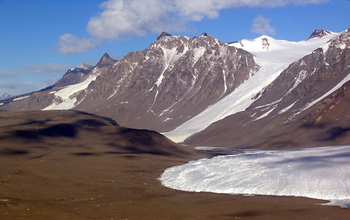
Laser mapping project shows effects of physical changes in Antarctica's Dry Valleys(图)
Laser mapping project physical changes Antarctica Dry Valleys
2017/9/4
Researchers funded by the National Science Foundation (NSF) have publicly released high-resolution maps of Antarctica's McMurdo Dry Valleys, a globally unique polar desert.The high-resolution maps cov...
Spatial-Temporal Mapping of Agro-Ecosystems and the need to build Thematic Legends
Remote Sensing Agriculture Mapping Land Use Classification Land Cover Generalization Monitoring
2015/7/30
fication systems, (ii) geomatics, being the scientific management of spatial information, and (iii) monitoring of climate, land cover
and land use changes. Simultaneously the spatial and temporal qu...
Mapping of QTL Associated with Fusarium Head Blight in Spring Wheat RL4137
Associated Spring Wheat
2014/3/11
Fusarium head blight (FHB) is a destructive disease of wheat worldwide. We aimed to map QTL for
FHB resistance in RL4137, a FHB resistant line derived from Frontana using 90 recombinant inbred lines...
QTL Mapping for chinese northern-style steamed bread specific volume
Wheat Doubled Haploid Quantitative Trait Loci CNSB Specific Volume
2013/3/4
In this study, quantitative trait loci (QTLs) with additive effects, epistatic effects for CNSB specific volume in bread wheat (Triticum aestivum L.), were studied in cultivars Huapei 3 and Yumai 57 (...
An investigation of 1:5000 scale photogrammetric data for cadastral mapping uses: A case study of Kastamonu-Taskopru
Turkish cadastre photogrammetric map cadastral map information system
2011/1/12
Cadastral surveys have been carried out in Turkey using different methods such as graphical, photogrammetrical, orthogonal, tachometric and digital techniques. National cadastral works require large s...
Mapping soil drainage classes of Amik Plain using Landsat images
Soil drainage remote sensing Landsat images
2010/9/10
Soil drainage is one of the important soil properties affecting plant growth, water transfer and solute transport in soils. Soil drainage is also an environmental component affecting irrigation and so...
Application of SLEMSA and USLE erosion models for potential erosion hazard mapping in south-eastern nigeria
topography erodibility tropics West Africa cartography
2008/11/24
Assessment of potential soil erosion aids in detailed farm planning and management. Two potential erosion hazard maps of Anambra and Enugu States of Nigeria were developed by the application of SLEMSA...
FINE MAPPING OF MILK YIELD QTL ON CHROMOSOMES 6 AND 20 IN GERMAN HOLSTEIN POPULATION USING MICROSATELLITE MARKERS
production traits microsatellite markers association analysis
2010/12/1
In German Holstein population a very signifi cant QTL with effects on milk yield trait (MY) was mapped on chromosome 6 and 20 to the interval BM143–ILSTS97 and AGLA29–ILSTS72, respectively. Where, thr...

